
Remote Sensing Fundamentals
Introduction to Remote Sensing
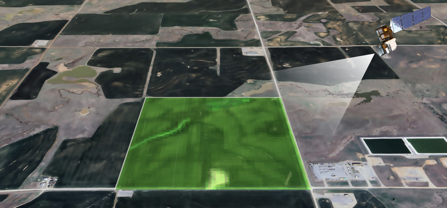
Remote sensing is the process of acquiring information from a distance. A phone camera is a remote sensing device, it records the light that is reflected off the subject and recording the light using a sensor. Through measuring the reflected energy, we can capture the data and start to analyze this information. Remote instruments provide data about Earth systems, enabling data-based decision-making for past, current, and future issues.
Why Remote Sensing Matters for Agriculture
For farmers and growers, remote sensing offers several practical benefits:
Field-Wide Visibility: See your entire operation at once, identifying problem areas that might be missed from the ground
Early Warning: Detect plant stress, moisture issues, or pest problems before they become visible to the naked eye
Historical Comparison: Track changes over time and compare current conditions to previous years
Resource Optimization: Make more efficient use of water, fertilizer, and other inputs by applying them only where needed
Weather Impact Assessment: Evaluate how weather events have affected your fields and plan a recovery strategy.
Figure 1: Remote sensing common terms. Pop ups describe the words with applications to farmers. Figure Credit: NASA Acres
Remote Sensing for Agriculture
Get a bird's-eye view of your fields and unlock new insights for your operation.
Click on a term to the left to learn more about the fundamentals of remote sensing and how it can benefit your farm or ranch.
Our Background, Mission, and Objectives
In 2022, NASA selected NASA Acres as its US-focused agriculture Consortium. With an initial 5-year award, our Consortium of over 50 organizations develops and transitions user-driven, satellite-based products to empower decisions from farm to policy levels.
To bring the value of Earth observation technology down to Earth to strengthen U.S. agriculture. We bridge the gap from space-to-farm and education-to-impact together with U.S. farmers and ranchers.
NASA Acres Core Principles for Agricultural Data Use
The NASA Acres Consortium recognizes the need for researchers to work closely with farmers to integrate "Ag Data" into the development and assessment of models for the mutual benefit of both communities. To support this, the NASA Acres Core Principles for Agricultural Data Use were born to help establish clear and transparent Ag Data Use Agreements.
- Create Simple Ag Data Use Agreements.
- Be Transparent about How Ag Data Will Be Used.
- No Commercialization without Farmer Consent.
- Anonymize Ag Data Wherever Possible.
Introduction to Remote Sensing
 Image: Solar energy from the Sun hits the Earth and is reflected. Sensors on NASA satellites detect this energy. Image Credit: NASA Acres
Remote sensing is the science of obtaining information from a distance, typically from aircraft or satellites. For farmers and ranchers, it means getting a bird's-eye view of their fields and pastures without having to be everywhere at once.
Imagine being able to see your entire operation at once, spotting potential irrigation issues, pest infestations, or nutrient deficiencies before they become visible to the naked eye. This tool can help save you time, resources, and ultimately improve your yields or livestock health.
How does it work? Objects absorb and reflect energy (like sunlight) in unique ways. Healthy plants, stressed plants, soil types, and water all have distinct "signatures." Remote sensors on satellites capture these differences, which can then be turned into useful information and maps.
Active vs. Passive Remote Sensing
 Image: Passive sensors use the energy from the sun reflected, while active sensors emit frequencies and detect the return. Image Credit: NASA
Remote sensing systems are broadly categorized based on their energy source:
Passive Remote Sensing: These sensors detect natural energy, like sunlight reflecting off your crops. Think of it like taking a photograph with a regular camera – it needs an external light source.
Active Remote Sensing: These sensors provide their own source of energy, like radar or lidar. This is like using a camera with a flash – it can work day or night.
Passive sensors are great for monitoring crop health on clear days.
Active sensors are powerful because they can "see" through clouds and work at any time. This is particularly useful for getting soil moisture information.
Image Size (Spatial Resolution)

Low resolution imagery (VIIRS)

Medium resolution imagery (Landsat)
Spatial resolution refers to the size of the smallest feature on the ground that a satellite sensor can distinguish. It’s often described by the ground area covered by a single pixel. Think of it as the level of detail you can see.
Common categories include:
- Low Resolution (e.g., VIIRS: 250m - 1km per pixel): Good for seeing large regional patterns.
- Moderate Resolution (e.g., Landsat: 30m per pixel): Excellent for most field-level agricultural analysis.
- High Resolution (e.g., Planet: <5m per pixel): Offers much more detail, good for identifying smaller variations.
For most farming and ranching operations, medium resolution provides a good balance of detail and cost.
Capabilities (Spectral Resolution)
 Image: Wavelengths of energy, some satellites can detect into the microwave, while others can detect into the ultraviolet. Image Credit: worldbank.github.io
Spectral resolution describes the ability of a sensor to detect different wavelengths of electromagnetic energy. Human eyes see visible light, but satellites can see a much wider range, including near-infrared, short-wave infrared, and thermal infrared.
Key spectral bands for agriculture include:
- Visible (Blue, Green, Red): Similar to what we see and used to create natural-color images.
- Near-Infrared (NIR): Healthy vegetation reflects NIR, a key band for assessing plant biomass and stress.
- Short-Wave Infrared (SWIR): Sensitive to moisture content in plants and soil.
- Thermal Infrared (TIR): Measures surface temperature and can indicate water stress in a plant.
You can get an early warning about plant stress. Different combinations of bands can help identify water stress, nutrient deficiencies, or even differentiate crop types.
Agricultural Applications

Healthy Field (NDVI)

Stressed Field (NDVI)
Remote sensing provides actionable data to support farm management:
- Crop Health & Stress Monitoring: Track vegetation to detect plant stress from drought, pests, or nutrient deficiencies early on.
- Irrigation Management: Identify over- or under-watered areas to optimize water use.
- Yield Estimation: Monitor crop growth and biomass throughout the season to help forecast yields.
- Pest & Disease Detection: Changes in plant reflectance can indicate early signs of pest attacks or disease outbreaks.
Many powerful remote sensing tools and datasets are available for free! For example, you can explore:
- GLAM for monitoring crop conditions.
- Crop-CASMA for soil moisture tracking.
- OpenET for evapotranspiration and irrigation water management data.
NASA Acres Projects & Capabilities
NASA Acres analyzes a wide range of agricultural characteristics to develop valuable insights and tools. These projects turn satellite data into actionable information for the field.
These capabilities can provide direct support for your management decisions, from optimizing irrigation and fertilizer application to monitoring forage for livestock and tracking crop development across the season.
Examples of our work include:
- Commodity Maps: Creating maps that identify what crops are growing where.
- Crop Stage Models: Modeling the growth stage of crops to inform management timing.
- Water Availability: Monitoring water resources for irrigation and land management.
- Evapotranspiration (ET): Measuring the amount of water used by plants.
- Rangeland & Pasture Productivity: Assessing forage quantity and quality for livestock.
- Soil Moisture: Providing data on soil moisture conditions at various depths.
- On-Farm Management Decisions: Developing tools to support precision agriculture.
What Satellites Reveal About Crops & Land

What You See (Visible Light)

What Satellites See (e.g., Near-Infrared)
Satellites equipped with specialized sensors can detect many aspects of crop, soil, and land conditions, often before they are apparent to the human eye:
- Biomass: health and density of vegetation.
- Chlorophyll Content: plant health and photosynthetic capacity.
- Water Status: identify water-stressed crops and soil moisture.
- Growth Stage & Patterns: track how crops are developing throughout the growing season.
Limitations of Remote Sensing
Remote sensing at the end of the day should be used as a tool in the toolbox.
- Ground-truth data: Satellite data requires field-based verification.
- Use case: The effectiveness of remote sensing fluctuates considerably depending on variables and management objectives.
- Future views: Remote sensing primarily captures historical conditions.
- Scale discrepancies: An individual pixel can encompass large areas, and subfield variations are often obscured.
NASA Acres is committed to data privacy for farmers. Working in this field, we can derive useful insights based on extensive scientific research for farmers use.